Category Archives: Lower Hills

Pokewalk No. 2: Rockridge BART and College Avenue

Chabot Avenue

Chabot Road offers idiosyncratic landscaping and a variety of architectural styles.

This walk sets you a challenge: Are you primarily interested in walking or gaming?

From the starting point at the Rockridge BART station escalator, you can see 38 Pokestops and five gyms. College Avenue is basically a sea of swirling blue cubes. If you want to get a workout, choose your pause points before you start, then grit your teeth and walk past the rest.

An advantage is the frequency of sidewalk benches that allow you to hunt without blocking foot traffic or looking obviously deranged. I picked a Sunday morning for this walk, which is a relatively quiet time on this busy commercial corridor.

MapHead north, past the Firestorm Community Mural and Chabot Middle School. You’ll pass the Dreyer’s Grand Ice Cream factory and College Avenue Presbyterian Church, designed by Julia Morgan and built in 1917. One of my favorite buildings in this neighborhood is the Claremont Day Nursery, a tiny Spanish Revival dollhouse with a distinctively old-school sign.

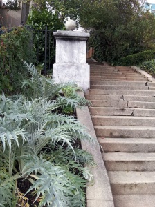
At the Claremont Diner, turn left down Claremont Avenue, then take a sharp left to go up Chabot Road. This street offers a menu of idiosyncratic landscaping and different East Bay architectural styles.

After you cross College Avenue, you’ll pass St. Albert’s College, a brick seminary with an extensive garden. If you have time and energy, it’s worth extending your walk farther into this neighborhood.

If you want to keep catching Pokemon, you’ll want to turn right on Presley Way, then back down Miles Avenue. It’s worth stepping into the BART parking lot to appreciate the deep space mural painted by Vista College students. But also note the Mid-Century Modern fire station immediately behind the middle school.

Cross under the BART station and make a quick loop by turning right on Forest Street and right on Shafter Avenue. You’ll pass several possibilities for coffee or breakfast as you head back to your starting point.

Tagged ,

What’s so bad about Pokewalking?

Sausal Creek, Dimond Park

There is a Pokemon in the middle of this creek, which used to be under a culvert. Maybe dont tell your kids about this one?

OK, it’s a fad, and OK, some people aren’t using good sense about where and how they play.

But Pokemon GO is also making me look at my neighborhood in new ways.

I walked two miles this morning, visited 16 Pokestops, faced defeat in two gyms and caught eight Pokemon.

I also saw a hummingbird, heard a red-tailed hawk, searched for fingerling trout, enjoyed several murals, checked the titles in a Little Free Library and found a church I had forgotten existed.

I felt nostalgic about Pokestop landmarks that have already changed: the little fire truck in Dimond Park that has been replaced with a brand-new tot lot, the hand-painted stars that used to decorate the fence around the old Blockbuster store, now demolished to its concrete pad. Even my favorite Chinese restaurant, closed for many months, is honored with a stop labeled “Ocean Temple.” Old-timers have a definite leg up in finding these spots.

This transitory nature of the world can sometimes cause humorous results. The in-game map shows dancing green sparks in the middle of a field in Dimond Park, but that field is now a restored section of Sausal Creek. It seems unlikely you’ll catch them all without getting your feet wet.

Nothing forces you to keep your face in your phone while hunting Pokemon. If you are familiar with the area, it’s easy to check what the Pokestop landmarks are before you set out and put your device back in your pocket till you get there. Don’t worry, it will vibrate when you pass a Pokemon.

DimondPokewalkStart this Pokewalk at Fruitvale Avenue and Lyman Road, at the brick steps that mark the entrance to Dimond Park. From this point, you should be able to see five gyms and 20 stops. You can plot your own route, but if you want to follow the one I’ve mapped for you, head into the park and downhill toward your left, past the redwood groves. You’ll follow the paved path along Sausal Creek past the Scout Hut, then take a detour to the Recreation Center.

Coming back past Lyons Pool, cross Sausal Creek to Cañon Avenue, a lovely, shaded street winding between neat bungalows. Look for trout in the calm spot to the left of the bridge.

Turn left onto MacArthur and head downhill, turning right onto Dimond Avenue to take a detour past Paws and Claws. Use Bienati Alley to get back to Fruitvale Avenue and the heart of the Dimond shopping district: Farmer Joe’s Market, La Farine, several cafes and markets.

Take Fruitvale back to MacArthur, turn right and right again onto Lincoln, which runs past a swirling blue mosaic and one of Oakland’s old fire houses. Go left and uphill on Champion at the firehouse, passing the Dimond Gateway Mural.

You can cut your walk to two miles by continuing uphill on Lincoln, rejoining my route at Sequoia School. Or go right and walk along MacArthur to Bret Harte Middle School, enjoying several mosaic murals on your way.

Head uphill on Coolidge Avenue, left on Madeline, left on Laguna and right on Scenic, through another neighborhood of modest but well-maintained bungalows. You’ll know you’re near Sequoia School when you pass the playground and another colorful mosaic mural.

Go uphill a block to Wilbur Avenue, then sharply downhill on Wilbur to Whittle Avenue, already described in this blog. Whittle will return you safely to Dimond Park.

Tagged ,

Sausal Creek daylighting, Dimond Picnic


Sausal Creek has been restored to its natural state as it passes through Dimond Park. (For decades, it passed under the park in a culvert.) 

If you want to check out the new paths and planting, the Friends of Sausal Creek will formally open it on Sunday.

Tagged

Tulip Show, Mountain View Cemetery

image

The grounds of Mountain View Cemetery are in bloom, but the real show this weekend is in the chapel, where local garden clubs and florists are pushing the limits between arrangements and art.

Tagged

Minor update: Dimond Canyon

image

It looks as if the medium-long-term solution to the Leimert Bridge shedding chunks of concrete is a construction-type scaffold over the trail. Not very esthetic, and it makes me think twice about using Leimert.

Tagged ,

Minor update: Sunset Trail gets Facelift

Volunteers are working to improve the Sunset Trail in Joaquin Miller Park. How cool would it be if the loop they are talking about here got built?

Contra Costa Times article

Minor Update: Leaves are changing?!

image

Lake Temescal this afternoon.

Minor update: Shepherd Canyon Parkway

The deadfall I noted last year is still blocking the upper trail in Shepherd Canyon Park. I normally disapprove of stepping off marked trails, but it seems this tree isn’t going anywhere soon, and neither are the construction fences around the soccer field. Substantial plant restoration work has been done, however, suggesting patience may be rewarded.

No. 51: Rockridge Park, Prospect Steps and Locarno Path

Margarido boulder

This chert boulder on Margarido Drive, covered with a wistaria vine, shows how the “Rock Ridge” neighborhood got its name.

Pass through the stately white pillars marking Rockridge Boulevard, and you quickly come to Rockridge Park, a green triangle randomly planted and with few amenities to welcome the passerby. The neighborhood around it, however, is full of interesting architecture and pedestrian-friendly — if aerobic — steps.Map of Prospect and Locarno Steps

Head up Rockridge Boulevard South, and you will soon see the Prospect Steps on your left, up what looks like an extended driveway. An early morning jogger is already using them to climb the hill. Unlike the Oakmore Steps, these haven’t been rebuilt in a while, and their treads tilt crazily where the bare trees are flexing their roots.

After the steps cross Margarido Drive, you should turn around from time to time, to catch your breath as well as the panoramic view across the city. The steps change their name to West Lane as they continue past Manchester Drive, and as you come over the top of the ridge, you have a second vista across the valley of Temescal Creek toward the Montclair Hills.

Locarno Steps

Locarno Path steps

Turn right on Ocean View Drive, and right again on Alpine Terrace. At the very end of Alpine is the Locarno Path, which will take you down to Acacia Avenue. Mindful of their Italian namesake, someone has planted artichokes at the foot of the first flight of steps.

Turning right on Acacia, you pass the occasional newer home or fenced-off empty lot reminds you that the 1991 firestorm touched this neighborhood. But for the most part, the homes are in the traditional styles of the mid-20th century or earlier, and as Acacia drops down the hill, you again catch a glimpse of the view their residents get to enjoy every day.

You will have to step into the street at this point, as the sidewalk disappears, but there is plenty of room for cars to pass safely. Turn right on Margarido, step back onto the sidewalk, and admire the large outcropping of chert on the left side. The owners of the house beneath are using it to hold up part of an extensive wistaria arbor.

At the end of the block, Margarido curves to the right, and by looking sharply near the antique-style light post, you will spot the unmarked pedestrian way that will return you to Rockridge Park. The entire loop is just under a mile.

Cool stuff in the neighborhood: The area around the Rockridge BART station is full of cafes and restaurants, from the elegant Oliveto to the popular Zachary’s Pizza and Cactus Taqueria. Shoppers can also peruse a number of boutiques and Pendragon Books.

More information: About the hunt for the original “Rock Ridge” and the Margarido boulder from the Oakland Geology blog. A four-mile walk that starts at Rockridge BART and includes part of this route is described on the Oakland Urban Paths blog.

Tagged , ,

No. 50: Oakmore Steps

Bridgeview Steps, Oakmore Highlands

The view back down the Bridgeview Steps, which help make the Oakmore Highlands pedestrian-friendly.

After Leimert Boulevard crosses Dimond Canyon, it enters a neighborhood of twisty little streets climbing the hills. The Oakmore Highlands, developed in the 1920s, were designed to offer homeowners spectacular views but convenient pedestrian access to the streetcar line that ran across the Leimert bridge. Four stairways offer these links and make for a short but steep route with some panoramic vistas across the city.

Start at the small commercial area on Leimert and walk up Arden Place. A green sign tells you when you’ve reached a public stairway. The first set of steps is utilitarian and short, but after crossing Bridgeview Drive, you begin a more serious climb up past steeply terraced yards. The neighbors have made an effort to make the stairs welcoming, with the occasional geranium or seasonal decoration marking their gates.

20121209_093703

The third set of stairs offers the best view of Oakland.

At the top of this second stair, you find Leimert Boulevard again. Turn and appreciate the view; a sliver of downtown Oakland and the port can be seen through a keyhole in the trees. Turn right on Leimert and look for the next public stair sign, which will be on your left around the sharp curve in the street.

This third set of steps is wooden, with a rustic feel. Be sure to look back again at the top for a panorama of Oakland and the San Francisco hills across the bay. Then turn right on Oakview Drive and walk to the end of the court. The final set of steps descends to your right beneath a heavy canopy of trees. Turning right on Hoover at the bottom of the steps, you have an easy walk downhill to Leimert.

Most of the homes in the Oakmore Highlands neighborhood are in the Mediterranean style, but some have fantastic details — ornate ironwork or Hobbit-style arches over their gates; Storybook touches like portholes in the brickwork.

It’s worth noting that as recently as 10 years ago, these steps were in such bad disrepair, they could hardly be used. The neighborhood took up their cause and persuaded the city to repair them in 2004.

Getting there: The closest bus service is to Park Boulevard, a short walk along Leimert Boulevard to Arden Place. Metered parking is available in the small neighborhood commercial area around Leimert and Arden.

Cool stuff in the neighborhood: Red Boy Pizza and Thai Bistro, at the corner of Arden Place and Leimert Boulevard, offer sit-down dining. Rocky’s Market, near the Leimert bridge, has cold drinks and a small selection of groceries.

More information: About the history of the Oakmore Steps and the neighborhood from the Oakmore Homes Association. Oakland Urban Paths led a five-mile walk that incorporated most of this route. Description and link to a map can be found on Oakland Local.

Tagged ,